Mount St. Helens and Mount Rainier - July 2000

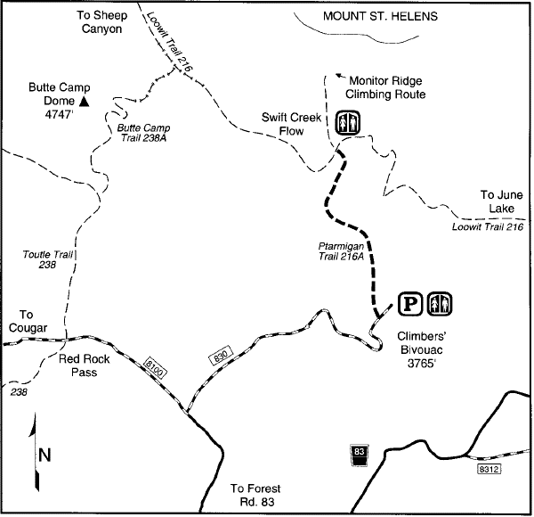
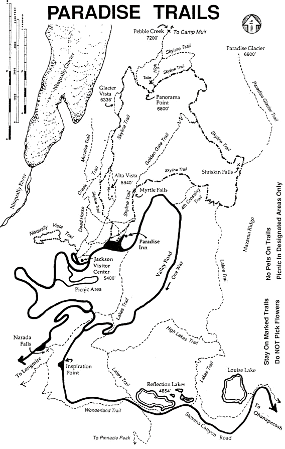
I summited Mount St. Helens via Monitor Ridge and made it to Camp Muir at Mount Rainier via the Muir Snowfield. Mount St. Helens was essentially a walk through the woods for the first half, a scramble over rocks and boulders for the next quarter, and like climbing a big giant ash dune for the last quarter. Mount Rainier was a walk through the alpine meadows for the first quarter and like climbing up a ski slope for the last 3 quarters. Picture walking from the ski lodge to the top of the mountain (twice). I had a really good time, most people who I talked to said 'you must be in really good shape' to do both mountains back to back. In 4 days I hiked about 33 miles and gained about 13,000 feet in elevation. Whew! Both of these ascents were excellent and I highly recommend going on either one. Just make sure you are in good shape before you go because both are steep with slippery footing.

Scrambling over rocks and boulders at Mount St. Helens Above the clouds. Looking back down Monitor Ridge. Notice the man in the very bottom of the picture for scale.
Looking up Monitor Ridge you can see where the rocks stop and the ash starts. An action photo above the clouds. Coming from 100 degree heat, 60 degrees and a lot of wind felt cold to me.
Looking up Monitor Ridge at the big giant ash dune. This is where it gets to be very hard going. Notice all the ash the wind is kicking up. That is the crater rim in the middle of the picture. If you look closely some of those small dots are people. At the summit. As soon as you hit the rim you are suddenly treated with an incredible view of the lava dome.
Mark on the summit of Mount St. Helens - 8,365 ft - on 8/11/00. A 4,600 ft elevation gain from the trail head Mark on the summit of Mount St. Helens - 8,365 ft - on 8/11/00. A 4,600 ft elevation gain from the trail head
Mark the next morning at a scenic overlook of Mount Rainier Mark overlooking the glaciers at Mount Rainier
This is where the trail stops and the Muir Snowfield starts. Look closely for the people to get an idea of the scale. An action photo of Mark climbing up the Muir Snowfield. It was downright hot on the snow and very hard going.
Camp Muir. This is where the people who are summitting Mount Rainier make their attempts from. I was not the only one cold here, everyone else was bundled up too as the wind was really strong. Looking back down the Muir Snowfield. Looks just like a ski slope that hasn't been groomed all season.
Mark at Camp Muir on Mount Rainier - 10,100 ft - on 8/12/00. A 4,600 ft elevation gain from the trail head Mark at Camp Muir on Mount Rainier - 10,100 ft - on 8/12/00. A 4,600 ft elevation gain from the trail head
Ptarmigan trail / Climber's Bivouac at Mt St. Helens Trails from Paradise that lead to Muir Snowfield on Rainier


Back to the hiking page

 Back to the home page